Magnetic Field in region of TOF
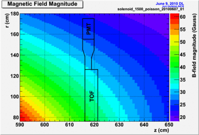
The field in the region of the TOF PMTs is given here. The purpose of this page is provide information that can be used to determine the appropriate amount of shielding for the TOF PMTs.
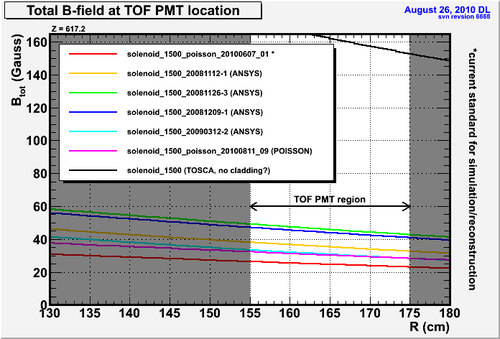
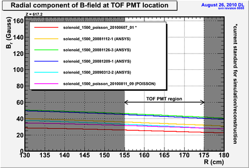
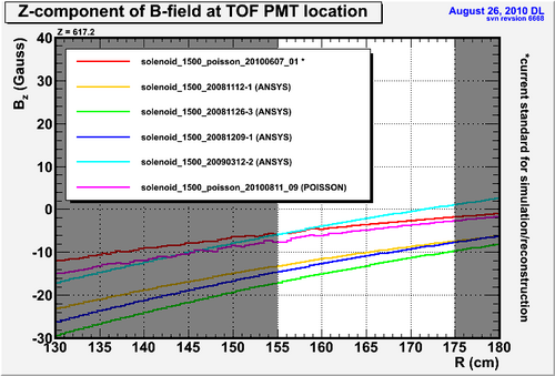
Several magnetic field maps exist based on the same or similar geometries for the coils and iron yoke. The small differences can lead to factors of 2 in the fringe fields. However, it appears that the maximum field we should expect is < 50 Gauss. The plots below show the field magnitude as well as the R and Z components for several maps in the region of the TOF PMTs. The plots are all at a single z location (z=617.2) with values plotted as a function of R. This field maps are all φ-symmetric. The TOF geometry, however is not. This means the plots indicate the values of the field for the tubes only in the cardinal directions (at x=0 or y=0). Other tubes will be at larger R values and so will see a smaller field magnitude, but also the field will be at a different angle w.r.t the PMT axis.
The information here should be considered as supplemental to GlueX-doc-912.
Note that some of the maps are special versions extended out to z=700cm. Historically, the maps only extended out to z=600cm. Specifically, the current default map used for simulation/reconstruction is the solenoid_1500_poisson_20090814_01 map based on the LASS magnet design. The solenoid_1500_poisson_20100607_01 map is identical except that it was extended further downstream in z[1].
The solenoid_1500_poisson_20100811_09 map is generated using a Babar style coil configuration. All other maps use the LASS coil configuration.

|
Color map of the magnitude of the B-field in the region of the TOF PMT experiencing the highest field. The TOF PMT+light guide are drawn. |
Questions/Comments --> davidl@jlab.org
- ↑ When generating a map with Poisson, several programs are run. The actual field calculation extends out to z=700cm, but the map is written out in a format we can digest by the SF7.exe program which we normally configure to only write out to z=600cm. It is only the configuration for this final program that is changed to make the extended version of the map.


